


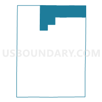
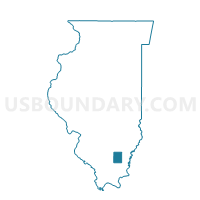
CROUCH Voting District, Hamilton County, Illinois
About
Outline

Summary
| Unique Area Identifier | 571068 |
| Name | CROUCH Voting District |
| County | Hamilton County |
| State | Illinois |
| Area (square miles) | 47.45 |
| Land Area (square miles) | 47.44 |
| Water Area (square miles) | 0.01 |
| % of Land Area | 99.97 |
| % of Water Area | 0.03 |
| Latitude of the Internal Point | 38.22123900 |
| Longtitude of the Internal Point | -88.48916280 |
Maps

Graphs
Select a template below for downloading or customizing gragh for CROUCH Voting District, Hamilton County, Illinois


Neighbors
Neighoring Voting District (by Name) Neighboring Voting District on the Map
- BARNHILL TWP Voting District, Wayne County, IL
- BEAVER CREEK Voting District, Hamilton County, IL
- BIG MOUND 1 Voting District, Wayne County, IL
- BIG MOUND 2 Voting District, Wayne County, IL
- DAHLGREN NO 1 Voting District, Hamilton County, IL
- DAHLGREN NO 2 Voting District, Hamilton County, IL
- MILL SHOALS 1 Voting District, White County, IL
- MILL SHOALS 2 Voting District, White County, IL
- OREL TWP Voting District, Wayne County, IL
- SOUTH CROUCH Voting District, Hamilton County, IL
Top 10 Neighboring County Subdivision (by Population) Neighboring County Subdivision on the Map
- Big Mound township, Wayne County, IL (1,742)
- Orel township, Wayne County, IL (1,420)
- Dahlgren township, Hamilton County, IL (1,220)
- Mill Shoals township, White County, IL (668)
- Barnhill township, Wayne County, IL (597)
- Crouch township, Hamilton County, IL (374)
- Beaver Creek township, Hamilton County, IL (271)
- South Crouch township, Hamilton County, IL (260)
Top 10 Neighboring Place (by Population) Neighboring Place on the Map
Top 10 Neighboring Elementary School District (by Population) Neighboring Elementary School District on the Map
Top 10 Neighboring Secondary School District (by Population) Neighboring Secondary School District on the Map
Top 10 Neighboring Unified School District (by Population) Neighboring Unified School District on the Map
- Hamilton County Community Unit School District 10, IL (7,974)
- Norris City-Omaha-Enfield Community Unit School District 3, IL (4,472)
- Wayne City Community Unit School District 100, IL (3,667)
Top 10 Neighboring State Legislative District Lower Chamber (by Population) Neighboring State Legislative District Lower Chamber on the Map
Top 10 Neighboring State Legislative District Upper Chamber (by Population) Neighboring State Legislative District Upper Chamber on the Map
Top 10 Neighboring 111th Congressional District (by Population) Neighboring 111th Congressional District on the Map
Top 10 Neighboring Census Tract (by Population) Neighboring Census Tract on the Map
- Census Tract 9549, Wayne County, IL (3,334)
- Census Tract 9553, Wayne County, IL (3,108)
- Census Tract 9733, Hamilton County, IL (2,784)
- Census Tract 9583, White County, IL (2,677)
Top 10 Neighboring 5-Digit ZIP Code Tabulation Area (by Population) Neighboring 5-Digit ZIP Code Tabulation Area on the Map
- 62859, IL (5,748)
- 62895, IL (2,022)
- 62828, IL (1,426)
- 62862, IL (364)
- 62887, IL (295)
- 62809, IL (142)